
[ad_1]
Parts of Northern Ireland have been flooded and people have been warned not to travel – as Storm Ciaran approaches the UK, bringing 90mph winds and up to 60mm of rain.
A Met Office amber warning for heavy rain is in place covering counties Antrim, Down and Armagh until 9am on Tuesday.
It has warned of between 25mm and 50mm of rain in places, and up to 100mm is also possible over higher ground.
An amber warning is the second highest level of alert, indicating “fast flowing or deep floodwater is possible, causing a danger to life”, as well as travel disruption and treacherous driving conditions.
Yellow weather warnings for rain have also been issued until 9am on Wednesday.
Check the latest weather forecast where you are

Met Office yellow and amber weather warnings for rain are in place on Tuesday across Northern Ireland
There were reports of flooding in Newry in Co Down on Monday after the city’s canal burst its banks, while in Dromantine, around 100 sheep were rescued after becoming stranded in a flooded field.
Met Eireann – the Irish National Meteorological Service – says spot flooding is expected in Ulster throughout the morning before clearing slowly northwards.
Stormont’s Department for Infrastructure said police were warning people not to travel while the amber warning is in effect.
It said: “These (Met Office) warnings follow an extremely wet weekend where flooding has already occurred on many roads.
“The persistent wet conditions on saturated ground and with higher river levels – this will inevitably lead to more localised flooding. Traffic disruption is possible, and the public are being asked to consider their journeys and take extra care if travel is necessary.
“It may be necessary to close roads or put temporary restrictions in place.”

A car drives through a flooded area of the A26 outside the village of Moira in Northern Ireland
Storm Ciaran is set to bring strong winds and heavy downpours to southern parts of England and Wales – with “unsettled” conditions forecast for much of the UK.
Met Office yellow weather warnings for rain and wind are in force every day until Thursday.
Gusts of 80mph are possible along the south coast of England, with 20 to 25mm of rain expected across southern and western areas, but potentially up to 40 to 60mm over higher ground, the Met Office said.
The forecaster warned already flood-affected areas following Storm Babet could get worse.

Met Office yellow weather warnings for rain and wind on Wednesday…

and on Thursday
Met Office meteorologist Marco Petagna said: “We’ve had various warnings in force across the UK over the last few days, and there are plenty more being issued for the next couple of days.
“The main focus in the next day or two is towards the east of Scotland and northeast England, where there is a yellow rain warning until 3am.
“There will be persistent rain up there, and then the focus for heavy showers will be across parts of southern and southeastern England and South Wales as well as parts of Northern Ireland with some heavy and sudden showers.”
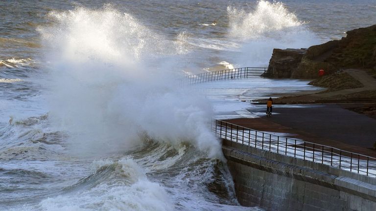
Waves crashing near Whitley Bay, on the north east coast of England
He said Tuesday was expected to be still unsettled but quieter before heavy winds and longer spells of rain develop on Wednesday night into Thursday as Storm Ciaran arrives.
“There are possible gusts of 80 to 90 miles an hour in some exposed southern areas. It’s probably quite a nasty storm this one.”
Read more UK news:
Briton trapped in Gaza sent sad face emoji by FCO official
Niece of Kenyan woman ‘murdered by British soldier’ calls on King to act
Police investigate serving officer over ‘racist and vile’ WhatsApp messages
The Environment Agency has issued more than 25 flood warnings.
Kate Marks, flood duty manager at the Environment Agency, said: “We urge people to stay safe on the coast and to remember to take extreme care on coastal paths and promenades.
“Flooding of low-lying coastal roads is also possible and people must avoid driving through floodwater, as just 30cm of flowing water is enough to move your car.”

The Thames Barrier will be closed for the 209th time
Meanwhile, the Thames Barrier in London will be closed from around 10.40am on Tuesday because “a high tide” is forecast “combined with high river flows”.
It will be the flooding defence system’s 209th closure, the first of this flood season.
[ad_2]
Source link